Thursday, December 30, 2010

Winter Solstice Measurements - very cool!

December was a record setting cloudy, snowy month here in the central western part of upstate New York; not idyllic for generating solar electric power! Yesterday after 16 overcaste days, the sun was out and the photovoltaic (P.V.) towers were generating electrical power!
Since the winter solstice was ten days ago and Sue & I had adjusted the angle of the solar panels to recieve the lower angle of winter sunlight more directly earlier in December; I wanted some empiral evidence that the 'angles' were worth the effort.

Below is a photo I took showing the angle of insolation near "solar noon". I printed, then scanned the photo with the protractor to measure the angle of insolation - Results: 24 degree angle. Next I took a profile photo of the P.V. towers (below right); scanned the photo and protractor to measure the angular position of the solar collecting panels - results: 64 degrees. If you look closely in the lower right hand corner, you can just barely see the sting which parallels the angle of the sun's rays ... it is visibly & very close to 90 degrees with the flat solar panel surface. This is not an official geometry proof ...but you can see that there is an advantage to adjusting the collecting panel angle as the seasons (angle of insolation) change.

(summer angle with higher solar noon sun angle) (winter angle with lower solar noon sun angle)

Below is a copy of our on line electrical energy production for the month of December, minus today - 12/31/10. Can you tell that the month was cloudy? You can see that the our P.V. system automatically shut down for a grid power outage on December 14th (See earlier blog post on 12/15).
The video clip is of the inverter display in our basement. The inverter converts the direct current (D.C) power from the P.V. system into alternating current (A.C), before going to the grid. As the display cycles through, you can see the amount of CO 2 kept out of the atmosphere; the number of Kilowatts of power currently being produced ('speed'); the total number of Kilowatts hours produced by our system('how far we've traveled'); the number of Kilowatt hours currently produced for this day ('how far we've traveled today'); and acknowedgement that the two towers ('system is working').

* (italics = analogy of energy display)

Below is our meter which indicates that electrical power is being produced for our use and the extra is being metered back into the grid.

Monday, December 27, 2010

Seasonal Analysis

Below is my attempt to graphically plot seasonal expectations.
I hope it is good for a laugh!
(click on the drawing to enlarge the drawing.)

Friday, December 24, 2010

Wednesday, December 15, 2010

Power Outage

Woke up this morning to realize that the power was out. Since I am an early riser, I assumed that the power was out in the greater Marbletown area. I proceeded to make coffee with the camp stove with light provided by the Coleman lantern and read for a predawn hour while the wood furnace pumped out toasty heat. Since we received another 6-8 inches of lake effect snow overnight, I blew out the driveway in the early morning light.
Still no power!?
It is now about 8am and a quick check with brother Steve, revealed that he had power and he reminded me that if the power were out, the generator at my parents' house would be running.
Hmmmn???
...guess I had better go check the line to my house.
It was fine. Okay, time to check with Kevin next door, since he is "upstream" of our branch joint power line. Kevin was on his cell phone talking to the power company as I arrived and waved me to take a look back down his driveway.
Yup! ... there was the problem.

Solar panels (background) would not turn on with the 'grid' disturbance.
NYSEG crew working in single digit temperatures prepare to set a new pole.
NYSEG crews prepare to raise the old pole, unwire it and rewire the new pole.
The old pole lashed to the new pole, will remain there until phone & cable companies detach and attach their lines to the new pole.
...7 hours later the Power's ON!

Sunday, December 12, 2010

Recalling another time and place

My niece is training to run her first marathon. Sarah's dad, my oldest brother was concerned about his daughters heavy mileage training in a recent phone call. Her training reminded him that I used to run competitive marathons in the 70's and 80's. Although now I walk and backpack miles; the conversation about marathoning reminded me of my first marathon in the spring of 1968 when I was a college Senior at Ottawa (Kansas) University and on the track team.
So I pulled an old scrape book of newspaper clipping and there I am!
(5th runner from the right) It was the 3rd Annual Humbolt, Kansas marathon. I was not in any kind of shape (mentally and/or physically) to handle the 26.2 mile, straight out and back course in rural Kansas. As the photo shows, the popularity of running a marathon was in it's infancy back then. It was my slowest and one of the most boring marathons of the 18 that I would to run over the next few decades. There were more cows and grass watching us run by then, compared to the cheering crowds on Beacon Avenue when finishing multiple runnings of the Boston Marathon years later on in the mid 70's ... and with much better results!

Thursday, December 9, 2010

Monday, December 6, 2010

Winter is back!

Lake effect snows have arrived. I estimated that about 6 inches of snow covered the ground this morning by looking out the basement door. When I actually stepped out to shovel the side walk I decided to check the snow fall with a yard stick.

Results:

11 inches and still snowing

Guess it is time blow out the driveway, after watching Sue drive out to an early morning dentist appointment in town.

Friday, November 12, 2010

Post Election Thought


... well, I am not really that pessimistic; but I can't help making a little fun of the state that has so much to offer it's 'EMPIRE' citizens.

Monday, October 25, 2010

Finished Compost

Below is a pile of finished compost made from last year's yard leaves. This compost contains no vegetable garden plant residues or weeds; so I am planning to use this compost on our 2011 vegetable garden to reduce the chance of introducing weeds or plant diseases. It is very nice material.
The pile was then covered to reduce the chance of nutrient loss over the fall, winter and early spring. I hope to send a compost sample into Penn State for complete nutrient analysis sometime this winter. Stay tuned!
Currently I am raking leaves and stacking them into a new pile shown below. A year from now these leaves; after I have turned the piles several times, will look like the finished compost in the top photo.

Thursday, October 14, 2010

Completing the Long Trail

I just returned from a 9 day backpack to the complete the northern third of the Long Trail in Vermont's Green Mountains. It was a fun, but exhausting trip that trekked along Green Mountain ridge line over the highest Vermont peaks. The trail was rugged; requiring boulder hoping and/or climbing, slogs through mud (...I packed only one pair of socks and my feet were wet 6 of the 9 trekking days) and walking through hardwood (maple, beech, yellow birch) and spruce forest. I drove to North Troy, Vermont just south of the Canandian/US border were Bob Prong (... a former math teacher at Midlakes H.S.) gave me a ride to the trail head at Applachain Gap (Vt Rt. 17). This was were Jason and I came off the Long Trail a month ago (...see blog post on September 8th). The hike was 120 miles long. The nights were cold, but the foliage and scent of fall were exhilerating.


Below are a series of random photos that will give you an impression of the trip.

Nights were spent in trail side shelters.
Ferns, metamorphic rock, moss and foliage.

Approaching the Vermonts highest peak - Mt. Mansfield as the rainy weather begins to break.
Muck, water and besure to stay on the trail = wet feet
Walking the Green Mountain ridge line continuous ups, downs, and back up over the next peak or "bump" meant a 300 - 600 ft elevation change to get from where the photo was taken to the top of the next peak or bump as shown in this photo.

The occassional evidence of past life in the Green Mountains

A view looking north into Canada on the horizon.
Sunrise over Stowe, Vermont
Ascent of Mt. Laraway required a walking along this mass of rock, dripping with water.
Looking north early in the morning.
Atop Jay Peak. My journey began beyond the furthest point visible in this photo over my head.
Looking back at Mt. Mansfield after crossing Smuggler's Notch. When I crossed Mt. Mansfield the day before, the winds forced me to stagger left & right in order to move forward, while be pelted by a driving rain, followed by stinging pelts of graupel (...BB sized pellets of snow) which turned the mountain top white. I found my self reviewing the signs of hypothermia as I desperately wanted to get off that mountain top... alive.

Ladders enable passage over some of the steeper trail sections.

Hikers had place rocks into lounge chair positions under a huge boulder.
Looking back as I ascended "the Camel Hump".
Passing through Devils' Gulch.

The US/Canandian border established in 1848 is just a line cut across the forest with markers. On my hike from the trail head back into North Troy to my truck, a US Border Patrol Officer stopped me to just check who I was and where I had been.

The video clip below is a typical view trekking along the Long Trail.
The following 360 degree video clip was taken from Mt. Belvidere.

Thursday, September 30, 2010

Slide Show of Trail Work On The FL Trail

In July and again in September I put in some volunteer time to help with bridge repairs/replacement on a segment of the Bristol Hills branch trail of the Finger Lakes Trail system. The specific area worked on was in the Prattsburg, NY area between Elmboise and Bean Station Roads. Helpping us complete the task were two teams of students from RIT (Rochester Institute of Technology).

Below are three links that will provide you with a nice progressive slide show of the trail work. The photos were taken by Lynda Rummel, Director of Trail Quality for the Finger Lakes Trails, who officially organized the trail work camps.

The link below shows photos of the bridges before and after our July weekend workcamp with the first group of RIT students and FLT volunteers

http://picasaweb.google.com/101133106692159636279/BeanStationBeforeAfterFirstCrew?authkey=Gv1sRgCL2Bwu_E5Y_rQA&feat=email#slideshow/5521784853036278770


This link and the next one show the bridge replacement/construction for the September 17 - 18th weekend with RIT students and FLT volunteers.

http://picasaweb.google.com/101133106692159636279/BeanStationBridgesConclusionLJensen?authkey=Gv1sRgCP22ufSw_pCIbw&feat=email#slideshow/5521770444600364114


http://picasaweb.google.com/101133106692159636279/BeanStationFinal?authkey=Gv1sRgCLvXzYWbqLDcVQ&feat=email#slideshow/5521764217640115218

Wednesday, September 8, 2010

Backpacking Again!

Jason and I recently returned from a 9 day backpacking trip that covered a 160 mile section of the Long Trail (LT); a 270 mile trail that follows the up and down boulder, strew ridge line of the Vermont's Green Mountains.
The LT map shows the distance we backpacked.

Backpacking over boulders, a scene so typical of the trail.

Some rewarding views, looking out across Vermont.


With backpacks left behind, a 0.2 mile climb up across boulders put us ontop of Killington Mt. (4100 ft.)


Not all of the trail was boulder strewn...


Jason atop Mt. Abraham (4000 ft) ... the air temperature was about 42 degrees F and damp.

Another view into the Vermont valley below.
The LT crosses the upper sides of several sky slopes.
Interesting trail art created by the stone contributions and their placement of passing hikers.
Another view looking back from where we had come.

Friday, August 27, 2010

Busy Bees!

Judging by the activity (140 incoming bees/minute), I would say the fall honey flow has begun, unlike two weeks ago when the incoming rate was about 20 bees/minute.

Turn the sound up and you can hear the "buzz"!

Saturday, July 31, 2010

More 'Stoned' Work at Wayne County Master Gardener office at CCE, Newark, NY

BEFORE
Herb bed with rotting, gray timber border.

AFTER
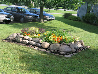
Stoned herb bed border.
... See any difference?


Friday, July 30, 2010

Trail Work

On the weekend of July 16 - 18th, I and two other Finger Lakes Trail representatives had a chance to work with five RIT (Rochester Institute of Technology) students and their two advisors repairing/rebuilding 8 bridges along the Bristol Hills branch of the FL Trail system near Prattsburg. It was a fun weekend filled with team work, jokes, swatting deer flies, avoiding poison ivy and getting the job done.